
Amazing Aerial View of Earth at Night
Postingan kali ini menyajikan Foto-foto yang diambil dari stasiun luar angkasa ISS mengenai Indahnya cahaya lampu kota kota di bumi saat malam hari dilihat dari ruang angkasa. Suatu pemandangan yang tidak banyak orang bisa melihatnya secara langsung ...
 The city lights of Spain and Portugal define the Iberian Peninsula in this photograph from the International Space Station (ISS). Several large metropolitan areas are visible, marked by their relatively large and brightly lit areas, including the capital cities of Madrid, Spain—located near the center of the peninsula’s interior—and Lisbon, Portugal—located along the southwestern coastline. The ancient city of Seville, visible to the north of the Strait of Gibraltar, is one of the largest cities in Spain. The astronaut view is looking toward the east, and is part of a time-lapse series of images.
The network of smaller cities and towns along the coastline and in the interior attest to the extent of the human presence on the Iberian landscape. The blurring of city lights is caused by thin cloud cover (image left and center), while cloud tops are dimly illuminated by moonlight. Though obscured, the lights of France are visible near the horizon line on the upper left, while the lights of northern Africa are more clearly discernable at right. The faint gold and green line of airglow—caused by ultraviolet radiation exciting the gas molecules in the upper atmosphere—parallels the horizon (or Earth limb).
The Iberian Peninsula is the southwestern-most of the European peninsulas (together with the Italian and Balkan peninsulas), and includes the Principality of Andorra, as well as the Kingdom of Spain and the Portuguese Republic. The approximately 590,000 square kilometer landmass is bounded by the Atlantic Ocean to the northwest, west, and southwest and the Mediterranean Sea to the east. Its northeastern boundary is marked by the Pyrenees mountain range.
 When viewed from the International Space Station (ISS), the night skies are illuminated with light from many sources. For example, the Midwestern United States presents a nighttime appearance not unlike a patchwork quilt when viewed from orbit.
The artificial light from human settlements appears with a characteristic yellow tinge. The green light of the aurora borealis also shines brightly in this view—even seeming to reflect off Earth’s surface in Canada. A small white patch of light is almost certainly lightning from a storm on the East coast (image top right). Part of the ISS appears across the top of the image.
This astronaut photograph highlights the Chicago metropolitan area as the largest cluster of lights, next to the dark patch of Lake Michigan. The other largest metropolitan areas include St. Louis, Minneapolis–St. Paul, and the Omaha–Council Bluffs region on the Nebraska–Iowa border. The northeastern seaboard lies just beyond the Appalachian Mountains, a dark winding zone without major cities.
City light clusters give an immediate sense of relative city size. Demographers have used nighttime satellite imagery to make estimates of city populations, especially in the developing world, where growth can be rapid.
The sense of scale changes significantly in oblique views. Des Moines is 200 kilometers from Omaha and 375 kilometers from Minneapolis, yet the distances appear roughly the same in this view.
In addition to the major metropolitan areas, the rectangular north-south-east-west layout of townships is clearly visible in the rural, lower left of the image. This pattern instantly gives the sense of north orientation (toward the top left corner) and is a distinctive characteristic of the United States that helps astronauts quickly know which continent they are flying over at night.
In contrast to the regular township pattern, interstate highways converge on St. Louis, Chicago, and other large cities, much like wheel spokes around a central hub. Rivers—major visual features in daylight—become almost invisible at night. The course of the Mississippi River appears as a slightly meandering zone from Minneapolis through St. Louis and continues out of the lower right corner.
 The brightly lit metropolitan areas of Torino (Italy), Lyon, and Marseille (both in France) stand out amidst numerous smaller urban areas in this dramatic astronaut photograph. The image captures the nighttime appearance of the France-Italy border. The southwestern end of the Alps Mountains separates the two countries. The island of Corsica is visible in the Ligurian Sea to the south (image top).
The full moon reflects brightly on the water surface and also illuminates the tops of low patchy clouds over the border (image center). This image was taken by an International Space Station (ISS) astronaut at approximately 11:55 p.m. local time, when the ISS was located over the France-Belgium border near Luxembourg.
 City lights of London, England were captured with a digital still camera by one of the Expedition Six crewmembers on the International Space Station (ISS). This nighttime view of the British capital shows the city’s urban density and infrastructure as highlighted by electrical lighting. Beyond lie isolated bright areas marking the numerous smaller cities and towns of the region and as far southeast as Hastings on the coast. London’s two major airports, Heathrow and Gatwick, are visible to the south of the city.
 A night time view of India-Pakistan borderlands is featured in this image photographed by an Expedition 28 crew member on the International Space Station. Clusters of yellow lights on the Indo-Gangetic Plain of northern India and northern Pakistan reveal numerous cities both large and small in this photograph. Of the hundreds of clusters, the largest are the metropolitan areas associated with the capital cities of Islamabad, Pakistan in the foreground and New Delhi, India at the top - for scale these metropolitan areas are approximately 700 kilometers apart. The lines of major highways connecting the larger cities also stand out. More subtle but still visible at night are the general outlines of the towering and partly cloud-covered Himalayan ranges immediately to the north (left). A striking feature of this photograph is the line of lights, with a distinctly more orange hue, snaking across the central part of the image. It appears to be more continuous and brighter than most highways in the view. This is the fenced and floodlit border zone between the countries of India and Pakistan. The fence is designed to discourage smuggling and arms trafficking between the two countries. A similar fenced zone separates India's eastern border from Bangladesh (not visible). This image was taken with a 16-mm lens, which provides the wide field of view, as the space station was tracking towards the southeast across the subcontinent of India. The station crew took the image as part of a continuous series of frames, each frame taken with a one-second exposure time to maximize light collection -- unfortunately, this also causes blurring of some ground features. The distinct, bright zone above the horizon (visible at top) is produced by airglow, a phenomena caused by excitation of atoms and molecules high in the atmosphere (above 80 kilometers, or 50 miles altitude) by ultraviolet radiation from the sun. Part of the ISS Permanent Multipurpose Module, or PMM, and a solar panel array are visible at right.
 Cities at night in northern China are featured in this image photographed by an Expedition 26 crew member on the International Space Station. This striking photograph features two of China's most populous cities Beijing and Tianjin both located in the northern part of the country near the Bohai Gulf. The United Nations estimated 2010 population for the Beijing metropolitan area is approximately 12 million, with the population of the Tianjin metropolitan area estimated to be over 7 million. Taken at night time, the image dramatically indicates the developed extent of both metropolitan areas. The smaller city of Langfang, located midway between Beijing and Tianjin, also is clearly visible as are several other smaller developed areas to the northeast. The dark regions surrounding the well-lit urban areas are mainly agricultural fields, with wheat and corn being the major crops. Beijing (also known as Peking) is one of the recognized ancient capital cities and the current capital of the People's Republic of China. The regular grid pattern of the city is clearly visible at lower upper right; concentric rings of major roadways around the city center have been added as the metropolitan area has expanded. Tianjin is a major trade center with connection to seaports on the Bohai Gulf. The city was established following the integration of the Grand Canal of China, a major artificial waterway extending from Beijing southwards to Hangzhou over a distance of 1,176 kilometers. This image was acquired by astronauts onboard the space station when it was located approximately 630 kilometers away (ground distance) over the Yellow Sea near the western coastline of North Korea. The flattened perspective of the urban areas is a result of the viewing angle and distance from the ISS. The city light patterns are very clear, indicating that there was little cloud cover or haze in the region at the time the image was taken.
 This is one of a series of night time images photographed by the Expedition 29 crew from the International Space Station. It features Rocky Mountains, Denver-Colorado Springs (center-right), Santa Fe-Albuquerque (low-center-right), US Great Plains cities: Dallas-Oklahoma City, Kansas City and Chicago.
 The metropolitan area of Milan (or Milano) illuminates the Italian region of Lombardy in a pattern evocative of a patchwork quilt. The city of Milan forms a dense cluster of lights in this astronaut photograph, with brilliant white lights indicating the historic center of the city where the Duomo di Milano (Milan Cathedral) is located. Large dark regions to the south (image left) contain mostly agricultural fields. To the north, numerous smaller cities are interspersed with agricultural fields, giving way to forested areas as one approaches the Italian Alps (not shown). Low, patchy clouds diffuse the city lights, producing isolated regions that appear blurred. The Milan urban area is located within the Po Valley, a large plain bordered by the Adriatic Sea to the south and the Italian Alps to the north. Milan has the largest metropolitan area in Italy, and the fifth largest in the European Union. It is one of Europe’s major transportation, industrial, and commercial hubs, and is also a global center of fashion and culture. It is considered an “alpha” world city by the Globalization and World Cities Research Network.
 This night time view of northwestern Europe is featured in this image photographed by an Expedition 28 crew member on the International Space Station. Several of the oldest cities of northwestern Europe are highlighted in this photograph taken at 00:25:26 Greenwich Mean Time (GMT). While the landscape is dotted with numerous clusters of lights from individual urban areas, the metropolitan areas of London (United Kingdom), Paris (France), Brussels (Belgium) and Amsterdam (Netherlands) stand out due to their large light "footprints". The metropolitan area of Milan, Italy is also visible at lower left. This photograph was taken with a short camera lens, providing the large field of view recorded in the image. To give a sense of scale, the centers of the London and Paris metropolitan areas are approximately 340 kilometers distant from each other. The image is also oblique, or taken while looking outward at an angle from the station; this tends to foreshorten the image, making the distance between Paris and Milan (approximately 640 kilometers) appear less than that of Paris to London. In contrast to the land surface defined by the city lights, the English Channel at right presents a uniform dark appearance. Similarly, the Alps (bottom center) to the north of Milan are also largely devoid of lights. While much of the atmosphere was clear at the time the image was taken, the lights of the Brussels metropolitan area are dimmed by thin cloud cover.
 City lights illuminate this night time view of southern California, Mexico's Baja California and the Gulf of Cortez, as photographed by one the Expedition 28 crew members onboard the International Space Station flying at altitude of approximately 220 miles. A 15-mm focal length was used to capture the time lapse image. The thin line of Earth's atmosphere is visible above the horizon.
 One of the Expedition 29 crew members aboard the International Space Station recorded this oblique view showing the Mediterranean Sea area, including the Nile River and the river's delta, and the Sinai Peninsula, on Oct. 15, 2011. Cyprus is visible at left. At first look, the image appears to have been photographed in daylight, but actually it was taken at 01:01:08 GMT. Some areas of the photo like the river and river delta appear as the brightest areas because of either man-made lighting (mostly incandescent) or man-made lighting reflected off nearby surfaces. The other areas appear to be illuminated naturally by moonlight, starlight, or back-scattered light from the atmosphere. A 20-mm focal length was used to record the image.
 This is one of a series of night time images photographed by one of the Expedition 29 crew members from the International Space Station. It features Central and Eastern Europe, extending from the Netherlands to Hungary and Italy to northern Poland. Overall, the view includes the Netherlands, Italy, Germany, Poland, and Hungary. When the photo was taken on Oct 2, 2011, the station was over Corsica at 43.18 degrees north latitude and 9.95 degrees east longitude.
 One of the Expedition 29 crew members aboard the International Space Station recorded this oblique view showing Eastern Europe at night. The image includes Budapest, Hungary in the foreground (center left) and Kiev, Ukraine in the distance (top center). A 50-mm focal length was used to record the image.
 This is one of a series of night time images photographed by one of the Expedition 29 crew members from the International Space Station. It features Aurora Australis, airglow, and parts of the southeast Indian Ocean. Nadir coordinates are 50.58 degrees south latitude and 138.28 degrees east longitude.


 Whether seen at night or during the day, the capital city of Brazil is unmistakable from orbit. Brasilia is located on a plateau (the Planalto Central) in the west-central part of the country, and is widely considered to be one of the best examples of 20th century urban planning in the world. One of its most distinctive design features-as seen from above-suggests a bird, butterfly, or airplane traveling along a northwest-southeast direction, and is made dramatically visible by city light patterns (center left, directly to the west of Lake Paranoa). Following the establishment of Brasilia in the early 1960s informal settlements began to form around the original planned city. Ceilandia, located to the west of Brasilia, was one such informal settlement. In 1970 the settlement was formalized by the government and is now a satellite city of Brasilia with its own distinct urban identity. The developed areas of Brasilia and its satellite cities are clearly outlined by street grid and highway light patterns at night in this photograph taken from the space station. The large unlit region to the northwest of the city is the Brasilia National Park (lower left); other dark regions to the south and southwest contain agricultural fields and expanses of Cerrado tropical savanna.
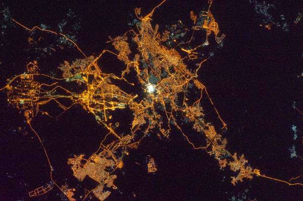


Foto-foto kota Makkah dan Madinah diatas memang mengagumkan. Ketika umumnya lampu-lampu malam tampak temaram kuning, Masjidil Haram dan Masjid Nabawi malah memancarkan cahaya putih yang sangat terang.
Terangnya ini melebihi terangnya lampu-lampu lain di Makkah dan Madinah yang digabungkan sekaligus. Dalam foto tampak semburat putih dari kedua masjid itu mengalahkan cahaya lain yang ada di kota tersebut. Masjidil Haram dan Masjid Nabawi tampak seperti permata yang putih di tengah aneka lampu kuning yang menyala di kota masing-masing.

Iberian Peninsula at Night

The network of smaller cities and towns along the coastline and in the interior attest to the extent of the human presence on the Iberian landscape. The blurring of city lights is caused by thin cloud cover (image left and center), while cloud tops are dimly illuminated by moonlight. Though obscured, the lights of France are visible near the horizon line on the upper left, while the lights of northern Africa are more clearly discernable at right. The faint gold and green line of airglow—caused by ultraviolet radiation exciting the gas molecules in the upper atmosphere—parallels the horizon (or Earth limb).
The Iberian Peninsula is the southwestern-most of the European peninsulas (together with the Italian and Balkan peninsulas), and includes the Principality of Andorra, as well as the Kingdom of Spain and the Portuguese Republic. The approximately 590,000 square kilometer landmass is bounded by the Atlantic Ocean to the northwest, west, and southwest and the Mediterranean Sea to the east. Its northeastern boundary is marked by the Pyrenees mountain range.
Midwestern USA at Night with Aurora Borealis

The artificial light from human settlements appears with a characteristic yellow tinge. The green light of the aurora borealis also shines brightly in this view—even seeming to reflect off Earth’s surface in Canada. A small white patch of light is almost certainly lightning from a storm on the East coast (image top right). Part of the ISS appears across the top of the image.
This astronaut photograph highlights the Chicago metropolitan area as the largest cluster of lights, next to the dark patch of Lake Michigan. The other largest metropolitan areas include St. Louis, Minneapolis–St. Paul, and the Omaha–Council Bluffs region on the Nebraska–Iowa border. The northeastern seaboard lies just beyond the Appalachian Mountains, a dark winding zone without major cities.
City light clusters give an immediate sense of relative city size. Demographers have used nighttime satellite imagery to make estimates of city populations, especially in the developing world, where growth can be rapid.
The sense of scale changes significantly in oblique views. Des Moines is 200 kilometers from Omaha and 375 kilometers from Minneapolis, yet the distances appear roughly the same in this view.
In addition to the major metropolitan areas, the rectangular north-south-east-west layout of townships is clearly visible in the rural, lower left of the image. This pattern instantly gives the sense of north orientation (toward the top left corner) and is a distinctive characteristic of the United States that helps astronauts quickly know which continent they are flying over at night.
In contrast to the regular township pattern, interstate highways converge on St. Louis, Chicago, and other large cities, much like wheel spokes around a central hub. Rivers—major visual features in daylight—become almost invisible at night. The course of the Mississippi River appears as a slightly meandering zone from Minneapolis through St. Louis and continues out of the lower right corner.
France-Italy Border

The full moon reflects brightly on the water surface and also illuminates the tops of low patchy clouds over the border (image center). This image was taken by an International Space Station (ISS) astronaut at approximately 11:55 p.m. local time, when the ISS was located over the France-Belgium border near Luxembourg.
London at Night

India-Pakistan Borderlands

Beijing and Tianjin, China at Night

Rocky Mountains/Great Plains at Night

Milan, Italy at Night

Europe at Night

California, Mexico's Baja California and the Gulf of Cortez

Mediterranean Sea Area at Night

Central and Eastern Europe at Night

Eastern Europe at Night

Aurora Australis and Airglow

Cairo and Alexandria, Egypt at Night

Istanbul at Night

Brazil at Night

UPDATE:
Kosmonot Rusia Anton Shkaplerov mengaku takjub melihat penampakan kota suci umat Islam, Makkah dan Madinah di mana lokasi Masjidil Haram dan Masjid Nabawi berada. Foto dibawah ini diambilnya dari luar angkasa. Makkah
Madinah
Foto-foto kota Makkah dan Madinah diatas memang mengagumkan. Ketika umumnya lampu-lampu malam tampak temaram kuning, Masjidil Haram dan Masjid Nabawi malah memancarkan cahaya putih yang sangat terang.
Terangnya ini melebihi terangnya lampu-lampu lain di Makkah dan Madinah yang digabungkan sekaligus. Dalam foto tampak semburat putih dari kedua masjid itu mengalahkan cahaya lain yang ada di kota tersebut. Masjidil Haram dan Masjid Nabawi tampak seperti permata yang putih di tengah aneka lampu kuning yang menyala di kota masing-masing.
Masjidil Haram dari dekat
Posting Komentar untuk "Amazing Aerial View of Earth at Night"